Beulah Floods and Flood Plains: Always Get to High Ground
Written by Dan Graham and shared on the Beulah Historical Society Facebook page on 09/23/26
In light of the unprecedented flooding Beulah is experiencing from the Aspen Acres fire, we wanted to share this short overview of Beulah’s previous historic floods written by BHS member, Dan Graham for the 1st Qtr 2026 BHS Newsletter.
Beulah Floods and Flood Plains: Always Get to High Ground
by Dan Graham, Beulah resident and BHS member
Floods occur on a regular basis. Through decades if not centuries the history of floods have become ingrained into society. “Do you remember the great Pueblo Flood of 1921?”
Beulah has been the location of numerous floods. Records of floods in Beulah Valley are very limited given the location and lack of scientific monitoring devices around the Valley. The Federal Emergency Management Agency develops Flood Insurance Risk Maps (FIRM). A FIRM issued by FEMA is based upon the 1-percent annual chance flood, also referred to as the base flood or 100-year flood. Records of floods and hydrology analysis are used in developing, updating and issuance of Flood Maps. Below is an illustration of the Beulah Valley FIRM.
The area in Blue shows the location of areas considered to be in the 100 year Flood Plain.
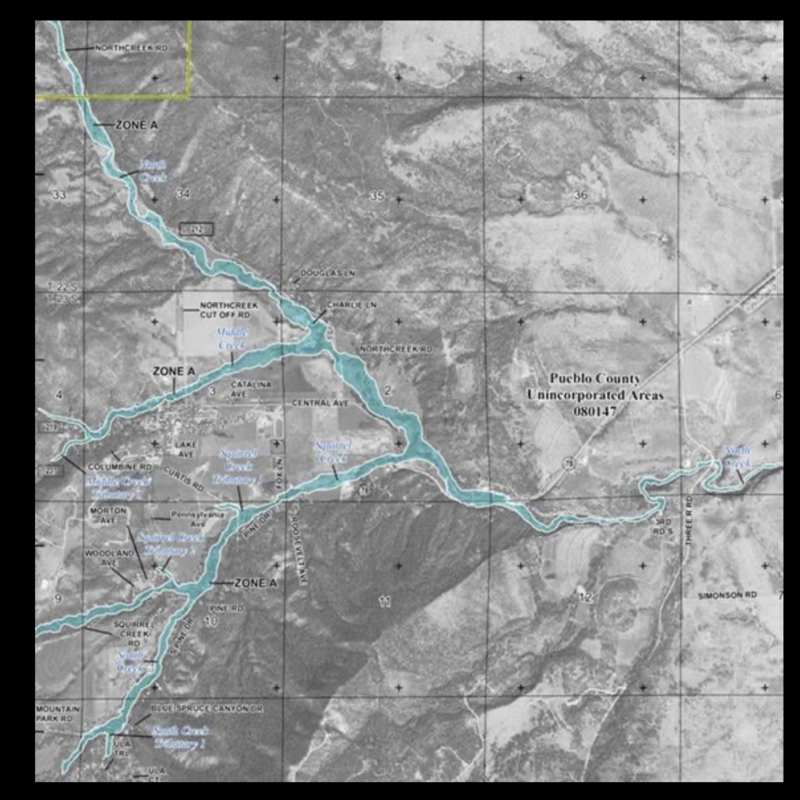
In Beulah the two streams most likely to flood have been North Creek and Squirrel Creek. Although, flooding along Middle Creek is more likely to occur after the Oak Ridge Fire. At one time in the past Middle Creek changed its path which also changed the location of the road. Squirrel Creek has also changed its path due to a flood.
The following Floods in Beulah Valley have been Recorded by personal accounts:
1901: The Pueblo Chieftain of May 23, 1901, included in a dispatch from Beulah: “On Monday evening [May 20] about 6 p.m., rain began to fall here with some hail. The storm increased until all the streams in the valley were out of their banks, and the oldest settlers * * * declared they have never seen such a rainfall. All the bridges were washed out.” Floods in Colorado, GEOLOGICAL SURVEY WATER-SUPPLY PAPER 997
1921: “The Geological Survey made an investigation of the resulting floods on the Arkansas River and tributary streams in June 1921 and compiled statements of local residents regarding the rainfall. In Boggs Flat, adjacent to the St. Charles Basin on the north, it was reported that 5 inches of rain fell in 30 minutes on June 3, and that 6 inches of water ran over the prairie. At Beulah a hard rain during the night of June 3-4 was reported.” Floods in Colorado, GEOLOGICAL SURVEY WATER-SUPPLY PAPER 997
1947: “After World War II, SIPRA considered making improvements to the Squirrel Creek facilities, but in August 1947 a major flood rendered those plans moot.
The flood swept through the Squirrel Creek Recreation District, destroying all of the bridges on Squirrel Creek Road and washing out parts of the road, rendering the campground and lodge inaccessible. The flood also washed away part of the campground and the middle section of the Cascade Trail.”(History of Colorado, Colorado Encyclopedia)
“In 1947 the melting snow caused flooding of the St. Charles River severe enough to change the course of the river from Squirrel Creek to the Host. Bridges were washed out. During that snow, Beulah was pretty well cut off from Pueblo.” (I Remember When ———— An interview with Norma Outhier by Elsa Frost, Beulah Historical Society)
August 2007: North Creek, including washed out bridge at Beulah Hill “Beulah — Flooding has washed out a bridge and a part of a state highway leading to the town of Beulah in southern Colorado.” (Denver Post, August 2, 2007)
May 2017: North Creek Drainage
“BEULAH — Relentless rain that began Wednesday afternoon combined with some hail created widespread flooding in the Beulah area that washed out culverts and roads causing their closure, and left numerous parts of the town covered in standing water.” (Pueblo Chieftain, May 11, 2017)